

 What is iMapInvasives?
iMapInvasives is used by New York State as the on-line, GIS-based data management system used to assist citizen scientists and natural resource professionals working to protect our natural resources from the threat of invasive species.
Where can I go to use iMapInvasives?
To visit iMapInvasives and check it out for yourself, click here.
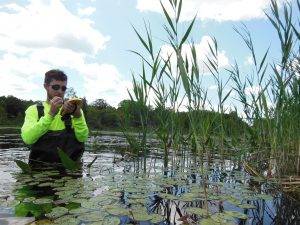
Credit: Zachary Simek, APIPP PRISM
Who uses iMapInvasives?
Within New York, iMapInvasives is used by natural and agricultural resource professionals, policy makers, educators, and the general public.
Many states use iMapInvasives, not only in the Northeast but across the country. One of the goals of iMapInvasives is to continue improving cross-jurisdictional data sharing. Join and start to contribute information to invasive species managers today!
What does iMapInvasives look like?
For information about different features on iMapInvasives click here.