

Background | New York Distribution Map
Background
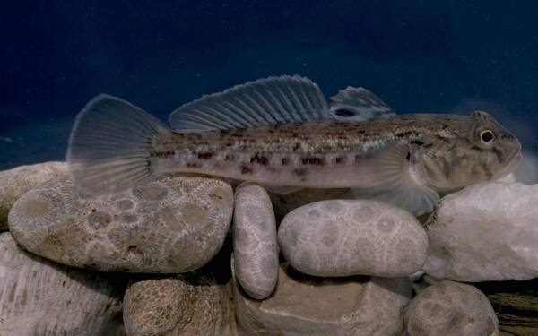
The round goby (Neogobius melanostomus), a native of freshwater and marine waters of Eurasia (particularly the Black and Caspian Seas and the Sea of Azov), was first observed in the Great Lakes Basin in 1990 when recreational anglers caught a specimen in the St. Clair River. It is believed that the species was introduced via international shipping ballast water discharge. Since that time, the fish has spread to all of the Great Lakes (Lake Erie, 1993; Lake St. Clair, 1994; Lake Michigan, 1994; Lake Superior, 1995; Lake Ontario, 1996; Lake Huron, 1998), where it is undergoing a dramatic population explosion (densities of several dozen per square meter of lakebed have been reported). Spread upstream to Lake Superior is believed to have been a result of interlake ballast water transport; downstream spread is most likely attributable to both ballast discharge and natural migration. Round gobies may prey on small fish such as darters, as well as lake trout, sculpin, and darter eggs and fry.
Adult gobies take over prime nearshore spawning sites and aggressively prevent use by native species. Long-term impacts are expected to include declines in native species populations. N. melanostomus has a well-developed lateral line which may give it a competitive advantage over native species feeding in turbid waters. Round gobies are also prolific breeders, spawning every 20 days during the spawning season.
Round gobies are problematic to anglers in that gobies are proficient bait thieves.
N. melanostomus has the beneficial impact of consuming large numbers of zebra mussels; however, given the contamination found in some populations of zebra mussels, this may result in bioaccumulation of toxics in gobies and biomagnification up the food chain to shorebirds and other species which consume the fish.
A link has been suggested between round gobies and the recent outbreaks of Type E avian botulism on Lakes Erie and Ontario.
New York Distribution Map
This map shows confirmed observations (green points) submitted to the NYS Invasive Species Database. Absence of data does not necessarily mean absence of the species at that site, but that it has not been reported there. For more information, please visit iMapInvasives.